OBJECTIVES
obtain and annually update information on the qualitative and quantitative forest parameters
(area, wood reserve, predominant species, completeness, bonitet, age and other characteristics)
obtain annual data on carbon reserves and carbon balance in forests
(main pool dynamics, volumes of carbon emission and carbon absorption)
obtain information on the impact of wildfires on forest and other terrestrial ecosystems
(areas covered by wildfire, degree of damage, post-fire litter and other destructive factors on forests and other terrestrial ecosystems)
provide tools for comprehensive analysis of long-term time series data related to the characteristics of forests and other terrestrial ecosystems,
including carbon reserves and carbon dynamics at various (from local to national) spatial levels
provide tools for integrated processing and analysis of remote sensing data and ground-based surveys
to verify the carbon monitoring results in forests and other terrestrial ecosystems
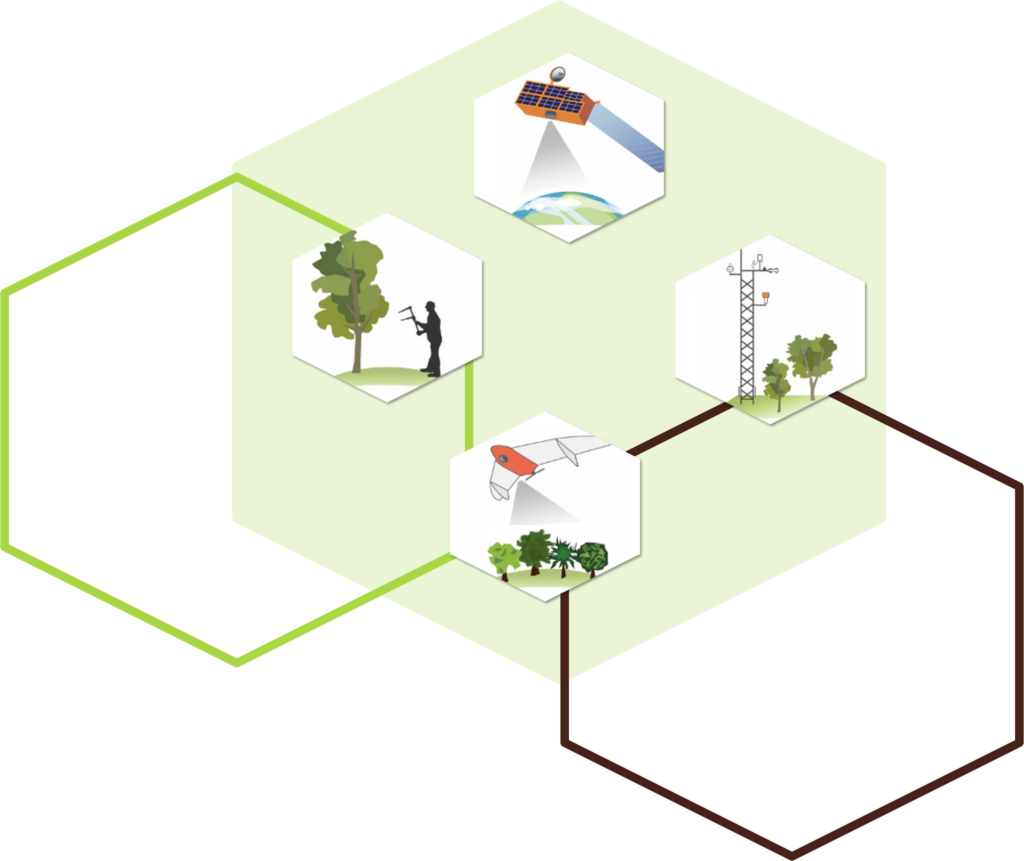
CENTRAL UNIT Integration of remote sensing and ground-based survey data
Data visualization Process simulation Data analysis Forecasting ACCESS SUBSYSTEM Infographics Gateway to data from external systems Mapping interface Software API interfaces
SPECIALIZED UNIT FOR GROUND-BASED MONITORING OF CARBON POOLS
Monitoring of vegetation cover features: species composition
parameters of vertical and horizontal structure
characteristics of soils, ground cover
SPECIALIZED UNIT FOR GROUND-BASED MONITORING OF GREENHOUSE GAS FLUXES Measurement of greenhouse gas fluxes (CO2, CH4, N2O, H2O)
Meteorological surveys
SPECIALIZED UNIT FOR AERIAL SURVEYS OF TERRESTRIAL ECOSYSTEMS
Monitoring of vegetation cover features: species composition
parameters of vertical and horizontal structure
Monitoring of the impact of negative factors
SHARED USE CENTER IKI-MONITORING
Satellite data collection
Streaming data processing for designing information products
Data processing and analysis
Providing of distributed access to satellite data
ЦЕНТРАЛЬНЫЙ УЗЕЛ Интеграция данных дистанционных и наземных наблюдений
Визуализация данных Моделирование процессов Анализ данных Прогнозирование ПОДСИСТЕМА ДОСТУПА Инфографика Шлюз к данным из внешних систем Картографический интерфейс Программные интерфейсы API
СПЕЦИАЛИЗИРОВАННЫЙ УЗЕЛ НАЗЕМНОГО МОНИТОРИНГА ПУЛОВ УГЛЕРОДА
Мониторинг характеристик растительного покрова: видовой состав
параметры вертикальной и горизонтальной структуры
характеристики почв, напочвенного покрова
СПЕЦИАЛИЗИРОВАННЫЙ УЗЕЛ НАЗЕМНОГО МОНИТОРИНГА ПОТОКОВ ПАРНИКОВЫХ ГАЗОВ Измерение потоков парниковых газов (CO2, CH4, N2O, H2O)
Метеорологические наблюдения
СПЕЦИАЛИЗИРОВАННЫЙ УЗЕЛ АВИАЦИОННОГО МОНИТОРИНГА НАЗЕМНЫХ ЭКОСИСТЕМ
Мониторинг характеристик растительного покрова: видовой состав
параметры вертикальной и горизонтальной структуры
Мониторинг воздействия негативных факторов
ЦЕНТР КОЛЛЕКТИВНОГО ПОЛЬЗОВАНИЯ “ИКИ-МОНИТОРИНГ”
Сбор спутниковых данных
Потоковая обработка данных для формирования информационных продуктов
Обработка и анализ данных
Обеспечение распределенного доступа к спутниковой информации